













 Tsavo National Park in Kenia
From mid-July to September and December to mid-March are the best months to visit both Tsavo National Parks. This park is a must see. The park is mountainous and green.
This page shows both the average monthly rainfall and the number of rainy days in Tsavo, Coast Province, Kenya. Long-term data from 1990 to 2020 was used to calculate these averages. Let's explore the details to provide you with a complete overview.
Tsavo's climate is marked by below-average rainfall, accumulating 485 mm (19 in) of precipitation yearly. The distribution includes a distinct dry season during certain months as shown in the precipitation charts below.
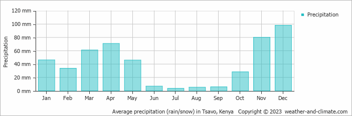
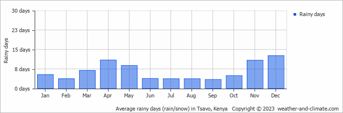
Significant seasonal changes in precipitation occur throughout the year. During the wettest month, December receives substantial rainfall, averaging 98 mm (3.9 in) of precipitation, recorded across 13 rainy days.
In contrast, the driest month, July brings less rainfall, with 3.4 mm (0.1 in) over 4 rainy days.
December, the wettest month, has a maximum daytime temperature of 32°C (90°F). During the driest month July you can expect a temperature of 30°C (86°F). For more detailed insights into the city's temperatures, visit our Tsavo Temperature page.
The map below shows the annual precipitation across Kenya. You can also select the different months in case you are interested in a specific month.
Tsavo's average annual precipitation is 485 mm (19 in). Let's compare this to some popular worldwide tourist destinations:
Chicago, USA, sees an annual precipitation of 1062 mm (42 in), with rain and snow contributing to its humid climate.
In Shanghai, China, the annual average precipitation is 1347 mm (53 in), with a humid subtropical climate.
Adelaide, Australia, enjoys 511 mm (20 in) of annual precipitation, with dry summers and wet winters.
Bangkok, Thailand, experiences a tropical monsoon climate with 1668 mm (66 in) of annual rainfall, with the heaviest precipitation occurring during September and October.
Precipitation amounts are measured using specific gauges installed at weather stations, collecting both rain and snow and any other type of precipitation. Rainfall is measured directly in millimeters, while that from snow and ice is obtained by melting it. Automated systems often incorporate heaters to make this easier.
Information from these stations is transmitted via Wi-Fi, satellite, GPS, or telephone connections to central monitoring networks. This information is immediately updated and integrated into weather models and forecasts.
Precipitation has a very strong role in determining the local climate and ecosystem:
For more detailed information about Tsavo's weather, including sunshine hours, humidity levels, and temperature data, visit our Tsavo Climate page.
Pick a month to see the average temperature, rainfall and sunshine in Tsavo - and find the best time to visit.
Temperature Rainfall
See the full Tsavo climate overview or explore weather in Kenya.
Where to go in October - average daytime high across popular destinations.
Mombasa 30°C (86°F) Diani Beach29°C (84°F) Watamu
 29°C (84°F) Malindi29°C (84°F) Kisumu
 27°C (81°F) Nairobi
 27°C (81°F) Nakuru
 25°C (77°F) Naivasha22°C (72°F)
 Need travel inspiration? Check out our bucket list articles and be inspired.
Tsavo National Park in Kenia
From mid-July to September and December to mid-March are the best months to visit both Tsavo National Parks. This park is a must see. The park is mountainous and green.
 The 10 best wildlife viewing sites in Kenya
Explore Kenya's top 10 safari parks in this guide, featuring the Maasai Mara, Amboseli, and more, for a spectacular wildlife adventure
 Not on the map - Yoga Teacher Training in Kenya
A yoga training with the rawness of mother Africa. In a place so untouched we really are walking on the same earth elephants roamed not so long ago.

 Visit Kruger Park in South Africa
Are you going to South Africa, then you cannot skip the Kruger Park. The Kruger Park is one of the most beautiful and largest safari parks in the world.