














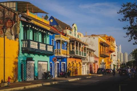
 The 10 most alternative cities in South America
Discover South America's top 10 alternative cities! From Valparaíso's vibrant streets to La Paz's high-altitude charm and Medellín's innovative spirit.
This page shows both the average monthly rainfall and the number of rainy days in Puerto Chico, Chile. These averages rely on historical data collected over 30 years, from 1990 to 2020. Let's now guide you through the details for a complete overview.
Puerto Chico has a relatively rainy climate with high precipitation levels, averaging 2528 mm (100 in) of rainfall annually. Despite the high annual total, it does experience a distinct rainy season during certain months. Examine our detailed charts below to understand these seasonal patterns.
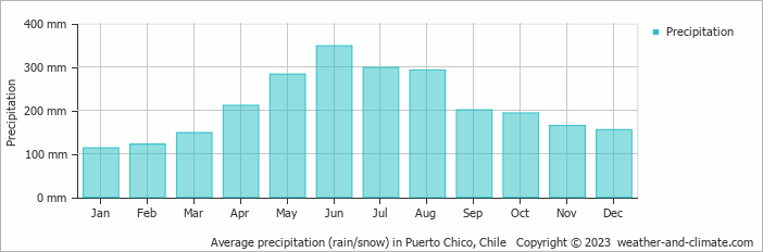
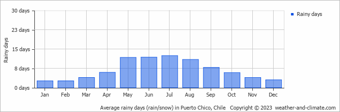
The seasons in Puerto Chico, bring significant changes in precipitation. The wettest month, June, receives heavy rainfall, with an average of 348 mm (14 in) of precipitation. This rainfall is distributed across 12 rainy days.
In contrast, the driest month, January, experiences much less rainfall, totaling 113 mm (4.4 in) over 3 rainy days. These distinct seasonal differences provide diverse experiences throughout the year.June, the wettest month, has a maximum daytime temperature of 12°C (54°F). The city receives 57 hours of sunshine in this period. During the driest month January you can expect a temperature of 20°C (68°F). For more detailed insights into the city's temperatures, visit our Puerto Chico Temperature page.
The map below shows the annual precipitation across Chile. You can also select the different months in case you are interested in a specific month.
Puerto Chico's average annual precipitation is 2528 mm (100 in). Let's compare this to some popular worldwide tourist destinations:
In Barcelona, Spain, the average annual precipitation is 644 mm (25 in), evenly distributed across the year with no extreme wet or dry seasons.
Meanwhile, Buenos Aires, Argentina, enjoys a humid subtropical climate with 1000 mm (39 in) of annual rainfall, mostly in the summer.
In Tokyo, Japan, the average annual precipitation is 1528 mm (60 in), with significant summer rains due to typhoon season.
Singapore, situated near the equator, gets 2581 mm (102 in) of rainfall annually, with no distinct dry season and consistent monthly precipitation.
Precipitation amounts are measured using specific gauges installed at weather stations, collecting both rain and snow and any other type of precipitation. Rainfall is measured directly in millimeters, while that from snow and ice is obtained by melting it. Automated systems often incorporate heaters to make this easier.
Information from these stations is transmitted via Wi-Fi, satellite, GPS, or telephone connections to central monitoring networks. This information is immediately updated and integrated into weather models and forecasts.
Tropical Rainforests: In tropical regions, rainfall is generally abundant year-round. Areas near the equator, like the Amazon rainforest, can receive up to 3000 mm (118 in) of rain annually.
Desert Regions: Deserts such as the Sahara and Arabian deserts typically see less than 250 mm (9.8 in) of rainfall annually. Rainfall tends to be infrequent, but when it does occur, it is often intense.
Temperate Zones: In temperate regions, precipitation tends to be more evenly distributed, though areas closer to the ocean may see more rain in the winter months, and areas further inland experience drier summers.
Polar Regions: Precipitation in polar regions, like Antarctica, is extremely low, often falling as snow. Average annual precipitation in Antarctica is less than 200 mm (7.9 in), with some areas receiving as little as 50 mm (2 in) annually.
For more detailed information about Puerto Chico's weather, including sunshine hours, humidity levels, and temperature data, visit our Puerto Chico Climate page.
Pick a month to see the average temperature, rainfall and sunshine in Puerto Chico - and find the best time to visit.
Temperature Rainfall Sunshine Humidity Wind Speed
See the full Puerto Chico climate overview or explore weather in Chile.
Where to go in October - average daytime high across popular destinations.
 San Pedro de Atacama
 23°C (73°F) Hanga Roa
 21°C (70°F) Santiago21°C (70°F) La Serena
 21°C (70°F) Viña del Mar17°C (63°F) Valparaíso16°C (61°F) Pucón
 15°C (59°F)
 Need travel inspiration? Check out our bucket list articles and be inspired.
The 10 most alternative cities in South America
Discover South America's top 10 alternative cities! From Valparaíso's vibrant streets to La Paz's high-altitude charm and Medellín's innovative spirit.
 Torres del Paine
Torres del Paine is an huge national park on the border with Argentina. It is possible to walk here along craters, high-rising mountain ridges, over glaciers and through vast majestic tundra.
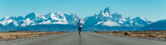 Explore Patagonia
A tour through Patagonia brings you to the end of the world. That’s why Patagonia is a bucket list destination for many. We recommend to visit Patagonia from November to early March.
 Enjoy the silence and peace in a spectacular landscape
This lodge guarantees privacy and exclusivity for those seeking to get away from mass tourism and enjoy the silence and peace in a spectacular landscape.