















 A paradise called Andaman Islands
Though officially Indian, the Andamans are nearer Myanmar, Indonesia, and Thailand, resulting in amazing, budget-friendly white-sand beaches.
This page shows both the average monthly rainfall and the number of rainy days in Bengaluru, Karnataka, India. These averages rely on historical data collected over 30 years, from 1990 to 2020. Let's now guide you through the details for a complete overview.
Generally, Bengaluru experiences moderate precipitation patterns, averaging 959 mm (38 in) yearly. However, this average masks significant seasonal variation, including a distinct dry season during certain months that are clearly visible in our monthly breakdown below.
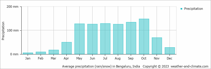
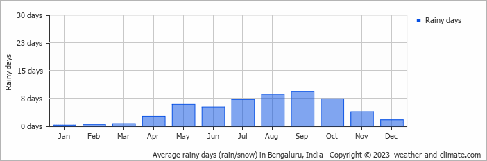
Significant seasonal changes in precipitation occur throughout the year. During the wettest month, October receives substantial rainfall, averaging 147 mm (5.8 in) of precipitation, recorded across 7 rainy days.
In contrast, the driest month, January brings less rainfall, with 4.7 mm (0.2 in) over 0 rainy days.
October, the wettest month, has a maximum daytime temperature of 29°C (84°F). The city receives 175 hours of sunshine in this period. During the driest month January you can expect a temperature of 29°C (84°F). For more detailed insights into the city's temperatures, visit our Bengaluru Temperature page.
The map below shows the annual precipitation across India. You can also select the different months in case you are interested in a specific month.
Bengaluru's average annual precipitation is 959 mm (38 in). Let's compare this to some popular worldwide tourist destinations:
The climate in San Francisco, USA, is influenced by coastal weather, with 469 mm (18 in) of rainfall mostly during the winter months.
In Shanghai, China, the annual average precipitation is 1347 mm (53 in), with a humid subtropical climate.
In Brisbane, Australia, the annual precipitation is 979 mm (39 in), making it wetter than Sydney.
Ho Chi Minh City, Vietnam, receives 1955 mm (77 in) of annual rainfall, with a pronounced wet season from May to November, typical of its tropical monsoon climate.
Precipitation amounts are measured using specific gauges installed at weather stations, collecting both rain and snow and any other type of precipitation. Rainfall is measured directly in millimeters, while that from snow and ice is obtained by melting it. Automated systems often incorporate heaters to make this easier.
Information from these stations is transmitted via Wi-Fi, satellite, GPS, or telephone connections to central monitoring networks. This information is immediately updated and integrated into weather models and forecasts.
Tropical Rainforests: In tropical regions, rainfall is generally abundant year-round. Areas near the equator, like the Amazon rainforest, can receive up to 3000 mm (118 in) of rain annually.
Desert Regions: Deserts such as the Sahara and Arabian deserts typically see less than 250 mm (9.8 in) of rainfall annually. Rainfall tends to be infrequent, but when it does occur, it is often intense.
Temperate Zones: In temperate regions, precipitation tends to be more evenly distributed, though areas closer to the ocean may see more rain in the winter months, and areas further inland experience drier summers.
Polar Regions: Precipitation in polar regions, like Antarctica, is extremely low, often falling as snow. Average annual precipitation in Antarctica is less than 200 mm (7.9 in), with some areas receiving as little as 50 mm (2 in) annually.
For more detailed information about Bengaluru's weather, including sunshine hours, humidity levels, and temperature data, visit our Bengaluru Climate page.
Pick a month to see the average temperature, rainfall and sunshine in Bengaluru - and find the best time to visit.
Temperature Rainfall Sunshine Humidity
See the full Bengaluru climate overview or explore weather in India.
Where to go in October - average daytime high across popular destinations.
New Delhi 34°C (93°F) Gurugram
 34°C (93°F) Jaipur35°C (95°F) Mumbai
 32°C (90°F) Hyderabad31°C (88°F) Chennai
 32°C (90°F) Bengaluru
 29°C (84°F) Kochi29°C (84°F)
 Need travel inspiration? Check out our bucket list articles and be inspired.
A paradise called Andaman Islands
Though officially Indian, the Andamans are nearer Myanmar, Indonesia, and Thailand, resulting in amazing, budget-friendly white-sand beaches.
 The 5 most beautiful monasteries in Ladakh
Explore Ladakh's spiritual essence through its incredible Buddhist monasteries. See architectural wonders, rich traditions, and serene landscapes in this guide.
 Sleeping under the stars and riding camels in Rajasthan
A desert safari in Jaisalmer is definitely one of the highlights during a visit to India. Spending a night in the desert is a great adventurous bucket list experience.
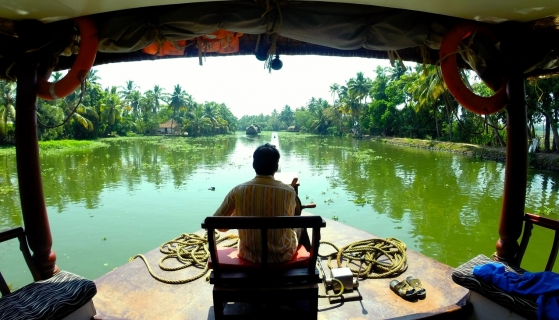 Avoid mass tourism on an eco boat in the backwaters of Kerala
We can tell you now how you can avoid being surrounded by tourists and at the same time minimize your impact on the environment.