

















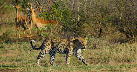
 Visit Kruger Park in South Africa
Are you going to South Africa, then you cannot skip the Kruger Park. The Kruger Park is one of the most beautiful and largest safari parks in the world.
This page shows both the average monthly rainfall and the number of rainy days in Winterton, KwaZulu-Natal, South Africa. The figures are based on a 30-year period (1990–2020) to provide a reliable average. Now, let's explore all the details to give you a full picture.
Winterton has a notably wet climate with abundant precipitation, recording 1058 mm (42 in) of rain/snowfall per year. It does, however, have a distinct dry and rainy season during certain months. Have a look at our detailed charts below to see how precipitation varies throughout the year.
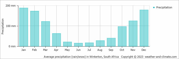
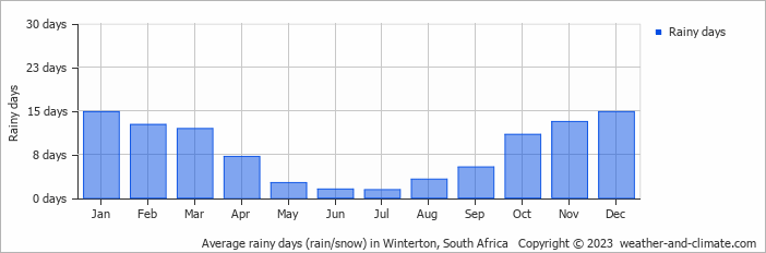
The climate in Winterton shows significant variation throughout the year. Expect 187 mm (7.4 in) of precipitation during the wettest month January, distributed over 15 rainy days.
In contrast, June offers drier and sunnier days, with around 15 mm (0.6 in) of rainfall over 2 rainy days.
January, the wettest month, has a maximum daytime temperature of 28°C (82°F). During the driest month June you can expect a temperature of 20°C (68°F). For more detailed insights into the city's temperatures, visit our Winterton Temperature page.
The map below shows the annual precipitation across South Africa. You can also select the different months in case you are interested in a specific month.
Winterton's average annual precipitation is 1058 mm (42 in). Let's compare this to some popular worldwide tourist destinations:
In Toronto, Canada, annual precipitation averages 964 mm (38 in), with snowy winters and rainy summers.
In Shanghai, China, the annual average precipitation is 1347 mm (53 in), with a humid subtropical climate.
Melbourne, Australia, has 690 mm (27 in) of rainfall annually, spread fairly evenly throughout the year.
Singapore, situated near the equator, gets 2581 mm (102 in) of rainfall annually, with no distinct dry season and consistent monthly precipitation.
Precipitation amounts are measured using specific gauges installed at weather stations, collecting both rain and snow and any other type of precipitation. Rainfall is measured directly in millimeters, while that from snow and ice is obtained by melting it. Automated systems often incorporate heaters to make this easier.
Information from these stations is transmitted via Wi-Fi, satellite, GPS, or telephone connections to central monitoring networks. This information is immediately updated and integrated into weather models and forecasts.
Precipitation has a very strong role in determining the local climate and ecosystem:
For more detailed information about Winterton's weather, including sunshine hours, humidity levels, and temperature data, visit our Winterton Climate page.
Pick a month to see the average temperature, rainfall and sunshine in Winterton - and find the best time to visit.
Temperature Rainfall
See the full Winterton climate overview or explore weather in South Africa.
Where to go in October - average daytime high across popular destinations.
Need travel inspiration? Check out our bucket list articles and be inspired.
Visit Kruger Park in South Africa
Are you going to South Africa, then you cannot skip the Kruger Park. The Kruger Park is one of the most beautiful and largest safari parks in the world.
 One of South Africa's most spectacular private game reserves
Sabi Sand Game Reserve is one of South Africa's most spectacular private game reserves. The chance that you see the entire Big Five is high in winter (June - August).
 Warm Days, Cool Nights: 8 Destinations With the Perfect Day-Night Temperature
Prefer warm sunny days but cool evenings? Compare eight destinations with daytime temperatures of around 25–30°C, cooler nights, low rainfall and plenty of sunshine.
 South Africa in November: Cape Town, Garden Route or East Coast?
Compare South Africa weather in November for Cape Town, Stellenbosch, Knysna, Durban and Johannesburg to find the driest and sunniest regions.