This page shows both the average monthly rainfall and the number of rainy days in Kahta, South Eastern Anatolia Region, Turkey.
The figures are based on a 30-year period (1990–2020) to provide a reliable average.
Now, let's break down all the details for a clearer picture.
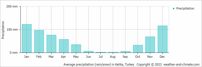
Generally, Kahta receives mid-range precipitation levels,
with 605 mm (24 in) annually.
The distribution varies significantly throughout the year, with a distinct dry season during certain months, as shown in our charts below.
Monthly Rainfall & Rainy Days
Monthly Precipitation Levels
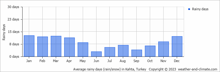
The average number of days each month with precipitation (> 0.2 mm (0.01 in))
Significant seasonal changes in precipitation occur throughout the year.
During the wettest month, January receives substantial rainfall, averaging 121 mm (4.8 in) of precipitation,
recorded across 13 rainy days.
In contrast, the driest month, August brings less rainfall, with 0.8 mm (0.03 in) over 7 rainy days.
January, the wettest month, has a maximum daytime temperature of 9°C (48°F).
During the driest month August you can expect a temperature of 38°C (100°F). For more detailed insights into the city's temperatures, visit our Kahta Temperature page.
Annual Rainfall in Turkey: City Comparison
The map below shows the annual precipitation across Turkey. You can also select the different months in case you are interested in a specific month.
Avg day temp (°C)
0°32°
Kahta vs World: Rainfall Compared
Kahta's average annual precipitation is 605 mm (24 in). Let's compare this to some popular worldwide tourist destinations:
In Toronto, Canada, annual precipitation averages 964 mm (38 in), with snowy winters and rainy summers.
In Shanghai, China, the annual average precipitation is 1347 mm (53 in), with a humid subtropical climate.
In Brisbane, Australia, the annual precipitation is 979 mm (39 in), making it wetter than Sydney.
Mumbai, India, experiences a tropical monsoon climate with 1860 mm (73 in) of annual rainfall, with the majority of precipitation happening during the monsoon season from June to September.
How is Precipitation Measured?
Precipitation amounts are measured using specific gauges installed at weather stations, collecting both rain and snow and any other type of precipitation. Rainfall is measured directly in millimeters, while that from snow and ice is obtained by melting it. Automated systems often incorporate heaters to make this easier.
Information from these stations is transmitted via Wi-Fi, satellite, GPS, or telephone connections to central monitoring networks. This information is immediately updated and integrated into weather models and forecasts.
Rainy Seasons: Many parts of the world have well-defined wet seasons where precipitation is distinctly higher. These are normally accompanied by lush vegetation and temperature patterns.
Dry Seasons: In areas where the climate is either desert or Mediterranean, the amount of precipitation is drastically reduced, leading to a shortage of water and arid conditions.
Interesting weather facts
Mawsynram in India is noted as being the wettest place on earth, with over 11 meters (36 feet) of rain falling every year.
In contrast, Antofagasta in Chile is among the driest places on the planet, getting less than 0.1mm (0.004 inches) per year, with some years recording virtually no rainfall.
Nearly 1,650 thunderstorm cells are estimated over the planet at any given time.
For more detailed information about Kahta's weather, including sunshine hours, humidity levels, and temperature data, visit our Kahta Climate page.
Kahta Weather by Month
Pick a month to see the average temperature, rainfall and sunshine in Kahta - and find the best time to visit.




















 An idyllic and beautiful place to stay and eat near Saklikent National Park in Turkey