Goroka Monthly Rainfall & Precipitation
This page shows both the average monthly rainfall and the number of rainy days in Goroka, Highlands Region, Papua New Guinea. The figures are based on a 30-year period (1990–2020) to provide a reliable average. Let's now guide you through the details for a complete overview.
Goroka experiences significant rainfall throughout the year, averaging 3323 mm (131 in) of precipitation annually.
Monthly Rainfall & Rainy Days
Monthly Precipitation Levels

The average number of days each month with precipitation (> 0.2 mm (0.01 in))
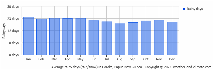
Significant seasonal changes in precipitation occur throughout the year. During the wettest month, February receives substantial rainfall, averaging 473 mm (19 in) of precipitation, recorded across 22 rainy days.
In contrast, the driest month, June brings less rainfall, with 121 mm (4.8 in) over 21 rainy days.
February, the wettest month, has a maximum daytime temperature of 24°C (75°F). During the driest month June you can expect a temperature of 23°C (73°F). For more detailed insights into the city's temperatures, visit our Goroka Temperature page.
Explore Goroka's Historical Precipitation: 2000-2026
Browse day-by-day precipitation records for Goroka spanning 27 years. Select any month and year to see actual rainfall and snowfall recorded on each day.
Annual Rainfall in Papua New Guinea: City Comparison
The map below shows the annual precipitation across Papua New Guinea. You can also select the different months in case you are interested in a specific month.
Goroka vs World: Rainfall Compared
Goroka's average annual precipitation is 3323 mm (131 in). Let's compare this to some popular worldwide tourist destinations:
New York City, USA, receives 1276 mm (50 in) of rainfall annually, with precipitation evenly distributed throughout the year.
Beijing, China, receives 560 mm (22 in) of annual precipitation, concentrated in the summer months.
In Brisbane, Australia, the annual precipitation is 979 mm (39 in), making it wetter than Sydney.
Ho Chi Minh City, Vietnam, receives 1955 mm (77 in) of annual rainfall, with a pronounced wet season from May to November, typical of its tropical monsoon climate.
Precipitation amounts are measured using specific gauges installed at weather stations, collecting both rain and snow and any other type of precipitation. Rainfall is measured directly in millimeters, while that from snow and ice is obtained by melting it. Automated systems often incorporate heaters to make this easier.
Information from these stations is transmitted via Wi-Fi, satellite, GPS, or telephone connections to central monitoring networks. This information is immediately updated and integrated into weather models and forecasts.
The proximity of a location to a large body of water can significantly affect its rainfall patterns:
- Ocean Influence: Coastal regions typically receive more rainfall due to the presence of moisture-laden winds from the ocean. These regions tend to have more humid climates and experience more frequent precipitation, especially in winter.
- Continental Climates: Areas further from the sea, such as inland or continental regions, experience less frequent rainfall and more extreme seasonal variations in precipitation.
- The U.S. has a significant number of thunderstorms every year, with over 14.6 million taking place across the world annually.
- Approximately 70% of lightning bolts strike land rather than oceans.
- A storm named John was the longest-lasting Pacific tropical storm, continuing for 31 days. As it crossed the dateline twice, it changed status from a hurricane to a typhoon and back to a hurricane.
For more detailed information about Goroka's weather, including sunshine hours, humidity levels, and temperature data, visit our Goroka Climate page.
Goroka Weather by Month
Pick a month to see the average temperature, rainfall and sunshine in Goroka - and find the best time to visit.

Goroka 3-Day Forecast
Temperature Rainfall
See the full Goroka climate overview or explore weather in Papua New Guinea.
Popular this month
Where to go in September - average daytime high across popular destinations.
 Rabaul
 29°C (84°F) Madang30°C (86°F) Port Moresby
 30°C (86°F) Kokopo29°C (84°F) Alotau28°C (82°F) Lae27°C (81°F) Goroka24°C (75°F) Mount Hagen22°C (72°F)