















 The 10 most alternative cities in South America
Discover South America's top 10 alternative cities! From Valparaíso's vibrant streets to La Paz's high-altitude charm and Medellín's innovative spirit.
This page shows both the average monthly rainfall and the number of rainy days in Machalilla, Ecuador. Long-term data from 1990 to 2020 was used to calculate these averages. Now, let's explore all the details to give you a full picture.
On average, Machalilla receives a reasonable amount of rainfall, with an annual precipitation of 767 mm (30 in). Despite this overall moderate level, the city experiences distinct dry season during certain months throughout the year, as illustrated in the precipitation charts below.
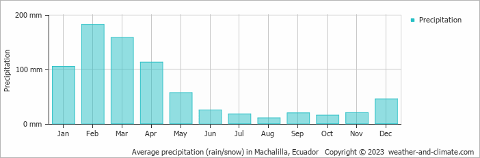
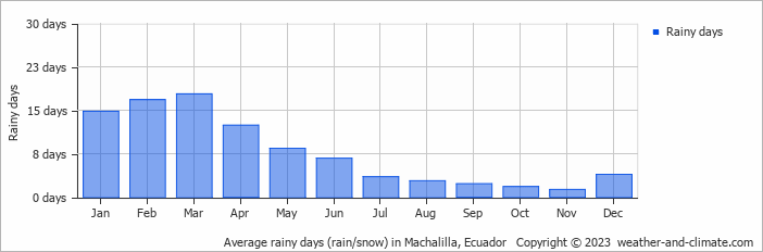
Machalilla can be quite wet during February, receiving approximately 182 mm (7.2 in) of precipitation over 17 rainy days.
In contrast August, experiences much drier conditions, with 10 mm (0.4 in) of rainfall, spread across 3 rainy days.
February, the wettest month, has a maximum daytime temperature of 29°C (84°F). During the driest month August you can expect a temperature of 27°C (81°F). For more detailed insights into the city's temperatures, visit our Machalilla Temperature page.
The map below shows the annual precipitation across Ecuador. You can also select the different months in case you are interested in a specific month.
Machalilla's average annual precipitation is 767 mm (30 in). Let's compare this to some popular worldwide tourist destinations:
The climate in San Francisco, USA, is influenced by coastal weather, with 469 mm (18 in) of rainfall mostly during the winter months.
Osaka, Japan, experiences 1507 mm (59 in) of rainfall annually, spread across the year with wetter summers.
In Tokyo, Japan, the average annual precipitation is 1528 mm (60 in), with significant summer rains due to typhoon season.
Bangkok, Thailand, experiences a tropical monsoon climate with 1668 mm (66 in) of annual rainfall, with the heaviest precipitation occurring during September and October.
Precipitation amounts are measured using specific gauges installed at weather stations, collecting both rain and snow and any other type of precipitation. Rainfall is measured directly in millimeters, while that from snow and ice is obtained by melting it. Automated systems often incorporate heaters to make this easier.
Information from these stations is transmitted via Wi-Fi, satellite, GPS, or telephone connections to central monitoring networks. This information is immediately updated and integrated into weather models and forecasts.
The proximity of a location to a large body of water can significantly affect its rainfall patterns:
For more detailed information about Machalilla's weather, including sunshine hours, humidity levels, and temperature data, visit our Machalilla Climate page.
Pick a month to see the average temperature, rainfall and sunshine in Machalilla - and find the best time to visit.
Temperature Rainfall
See the full Machalilla climate overview or explore weather in Ecuador.
Where to go in October - average daytime high across popular destinations.
 Guayaquil
 29°C (84°F) Montañita
 26°C (79°F) Puerto Ayora26°C (79°F) Salinas24°C (75°F) Puerto Baquerizo Moreno
 23°C (73°F) Quito
 19°C (66°F) Baños18°C (64°F) Cuenca16°C (61°F)
 Need travel inspiration? Check out our bucket list articles and be inspired.
The 10 most alternative cities in South America
Discover South America's top 10 alternative cities! From Valparaíso's vibrant streets to La Paz's high-altitude charm and Medellín's innovative spirit.
 The Galapagos Islands
The Galapagos Islands is one of the most beautiful places on earth. If you want to see the origins of our planet with your own eyes, you should travel here.
 A rain forest hotel in the clouds
This is not "just a lodge". It is a sanctuary of peace and nature for those who like to stay in the heart of nature with minimal environmental impact.

 Visit the Rainbow Mountains
The Rainbow Mountain (Vinicunca) is acolored rainbow mountain that will steal your heart forever and the view from the top will take your breath away.