



















 7 of the most budget-friendly destinations in Europe
Discover Europe's top budget-friendly destinations including Budapest, Kotor, Krakow, and more, perfect for affordable and exciting travel.
This page shows both the average monthly rainfall and the number of rainy days in Foz do Arelho, Centro Region, Portugal. The numbers reflect climate data gathered over a 30-year period, from 1990 to 2020. Let's now guide you through the details for a complete overview.
Generally, Foz do Arelho experiences moderate precipitation patterns, averaging 660 mm (26 in) yearly. However, this average masks significant seasonal variation, including a distinct dry season during certain months that are clearly visible in our monthly breakdown below.
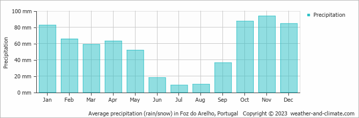
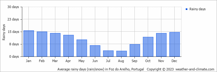
Significant seasonal changes in precipitation occur throughout the year. During the wettest month, November receives substantial rainfall, averaging 94 mm (3.7 in) of precipitation, recorded across 14 rainy days.
In contrast, the driest month, July brings less rainfall, with 8.8 mm (0.3 in) over 3 rainy days.
November, the wettest month, has a maximum daytime temperature of 18°C (64°F). The city receives 138 hours of sunshine in this period. During the driest month July you can expect a temperature of 24°C (75°F). For more detailed insights into the city's temperatures, visit our Foz do Arelho Temperature page.
The map below shows the annual precipitation across Portugal. You can also select the different months in case you are interested in a specific month.
Foz do Arelho's average annual precipitation is 660 mm (26 in). Let's compare this to some popular worldwide tourist destinations:
In Lisbon, Portugal, the average annual precipitation is 774 mm (30 in), characterized by wet winters and dry summers typical of the Mediterranean climate.
Meanwhile, Buenos Aires, Argentina, enjoys a humid subtropical climate with 1000 mm (39 in) of annual rainfall, mostly in the summer.
Adelaide, Australia, enjoys 511 mm (20 in) of annual precipitation, with dry summers and wet winters.
Singapore, situated near the equator, gets 2581 mm (102 in) of rainfall annually, with no distinct dry season and consistent monthly precipitation.
Precipitation amounts are measured using specific gauges installed at weather stations, collecting both rain and snow and any other type of precipitation. Rainfall is measured directly in millimeters, while that from snow and ice is obtained by melting it. Automated systems often incorporate heaters to make this easier.
Information from these stations is transmitted via Wi-Fi, satellite, GPS, or telephone connections to central monitoring networks. This information is immediately updated and integrated into weather models and forecasts.
The proximity of a location to a large body of water can significantly affect its rainfall patterns:
For more detailed information about Foz do Arelho's weather, including sunshine hours, humidity levels, and temperature data, visit our Foz do Arelho Climate page.
Pick a month to see the average temperature, rainfall and sunshine in Foz do Arelho - and find the best time to visit.
Temperature Rainfall Sunshine Humidity
See the full Foz do Arelho climate overview or explore weather in Portugal.
Where to go in October - average daytime high across popular destinations.
Need travel inspiration? Check out our bucket list articles and be inspired.
7 of the most budget-friendly destinations in Europe
Discover Europe's top budget-friendly destinations including Budapest, Kotor, Krakow, and more, perfect for affordable and exciting travel.

 Warm Sea Without Extreme Heat: 8 Beach Destinations With Comfortable Weather
Love warm seawater but not extreme heat? Compare eight beach destinations where the sea stays warm while daytime temperatures remain comfortable.
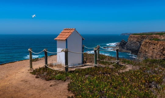
 Alentejo, where time stands still
The quiet region is known for its rolling green hills and it is a true hiking paradise. Architectural highlights can be found in the castles, ancient monasteries or when exploring the countless charming villages.
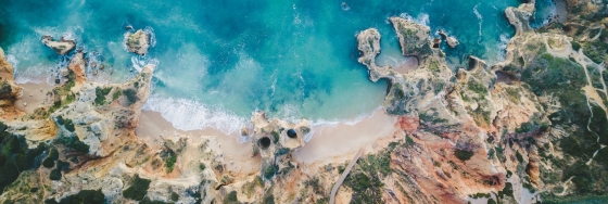 An eco-friendly guide to Lagos travel
Lagos, Portugal is a great place to visit while being careful about your environmental footprint. Here you find some tips about environmentally places to stay, where to eat and how to get around in the area.