


















 Warm Sea Without Extreme Heat: 8 Beach Destinations With Comfortable Weather
Love warm seawater but not extreme heat? Compare eight beach destinations where the sea stays warm while daytime temperatures remain comfortable.
The average annual maximum temperature in Valls, Catalonia, Spain is 22°C (72°F), with daytime highs ranging from 14°C (57°F) in January to 31°C (88°F) in July. This page covers monthly averages, day-night differences, and how Valls compares to cities worldwide.
Visitors to Valls will encounter a climate influenced by big temperature differences across the year. Nighttime temperatures range from 20°C (68°F) in July to 4°C (39°F) in January.
The chart below illustrates the average maximum day and minimum night temperatures in Valls by month:
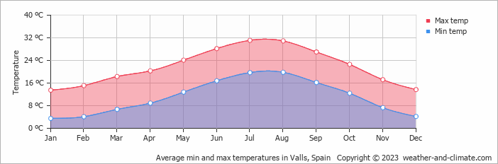
The coldest point of the day usually falls between 4 AM and 6 AM, with temperatures peaking around 3 PM. July, the city's warmest month, gets 307 hours of sunshine.
The chart below shows the average temperature throughout the year:
The map below shows the annual temperature across Spain. You can also select individual months if you want to compare a specific time of year.
Valls's average annual maximum temperature is 22°C (72°F). To put that in context, here's how it compares to a few well-known destinations:
Seville, Spain averages 23°C (73°F) a year, one of the warmer cities in Western Europe, with long hot summers.
Glasgow, Scotland averages 13°C (55°F) a year, mild but often grey, with cold winters and rarely hot summers.
Buenos Aires, Argentina averages 23°C (73°F) a year, with hot summers and mild winters, and seasons reversed compared to Europe.
Melbourne, Australia averages 20°C (68°F) annually, known for unpredictable weather, with four seasons sometimes happening in one day.
Climate temperature data is typically calculated as a 30-year average. This smooths out year-to-year variability and gives a more reliable picture of what a place is actually like, rather than what happened in any single unusual year.
The readings come from a range of sources, land-based weather stations, ocean buoys, ships, and satellites. That data is collected by weather services around the world, then pooled, quality-checked, and averaged to produce the climate records you see here.
For cities and regions with significant elevation, altitude is one of the biggest factors shaping local temperatures. As a rule of thumb, temperatures fall by around 6°C for every 1,000 metres gained, so a city at 2,000 metres will typically be around 12°C cooler than a city at sea level in the same region. Higher ground also tends to see more dramatic day-to-night temperature swings, since thinner air loses heat faster after sunset.
For more on Valls's weather, including monthly rainfall, sunshine hours, and humidity, visit our Valls climate page.
Pick a month to see the average temperature, rainfall and sunshine in Valls - and find the best time to visit.
See the full Valls climate overview or explore weather in Spain.
Where to go in October - average daytime high across popular destinations.
Need travel inspiration? Check out our bucket list articles and be inspired.
Warm Sea Without Extreme Heat: 8 Beach Destinations With Comfortable Weather
Love warm seawater but not extreme heat? Compare eight beach destinations where the sea stays warm while daytime temperatures remain comfortable.

 El Hierro: The smallest Canary island without mass tourism
Mainly nature lovers and those seeking tranquility go to El Hierro. The island is know for its beautiful mountains and you can wonder around for days here.
 Spain in October: Where Is It Warmest and Sunniest?
Discover where Spain is warmest in October, with climate comparisons for Seville, Alicante, Málaga, Tenerife, Madrid and Barcelona.
 Visit national Park El Teide
This national park is truly a unique place that you should not miss. You will find landscapes that seem to come from another plane and you will feel tiny in these impressive surroundings.