

















 The 10 most beautiful historical towns in Italy
Discover Italy's top 10 historic towns, featuring breathtaking medieval architecture and deep-rooted history, ideal for enthusiasts of extraordinary cities.
Average temperatures, rainfall, sunshine and the best time to visit Camino al Tagliamento.
 –
–
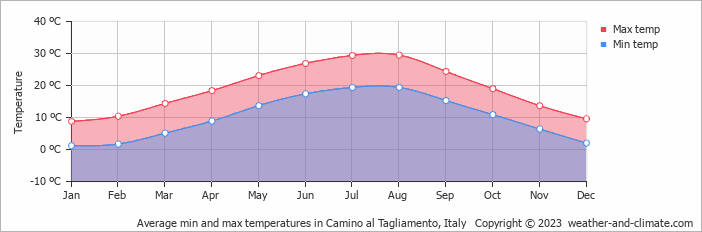
Camino al Tagliamento, Friuli Venezia Giulia, Italy, experiences significant temperature variation throughout the year. Summers bring daytime highs of 30°C (86°F) in August, while winters cool to 9°C (48°F) in January.
With around 1379 mm (54 in) of annual rain/snowfall, Camino al Tagliamento has a notably wet climate. However, this rain/snowfall is not evenly distributed, the city has warm summers and cold winters. The wettest month is November. July is the sunniest month, averaging 8.1 hours of sunshine per day.
Pick a month to see the average temperature, rainfall and sunshine in Camino al Tagliamento - and find the best time to visit.
Depending on the time of the year, temperatures range from comfortable to chilly in Camino al Tagliamento. Average daytime temperatures reach a comfortable 30°C (86°F) in August. In January, the coolest month of the year, temperatures drop to a chilly 9°C (48°F).
At night, temperatures range from around 19°C (66°F) in August to 1°C (34°F) in January.
Check out our detailed temperature page for more information.
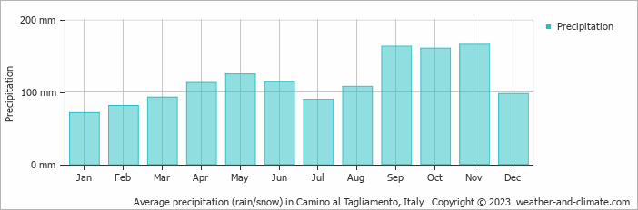
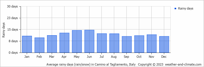
Camino al Tagliamento has a relatively rain/snowy climate with high precipitation levels, averaging 1379 mm (54 in) of rain/snowfall annually. Camino al Tagliamento can be quite wet during November, receiving approximately 166 mm (6.5 in) of precipitation over 12 rainy days.
In contrast, during the driest month (January), you will experience much drier conditions, with 71 mm (2.8 in) of precipitation spread across 11 rainy days. For more details, please visit our Camino al Tagliamento Precipitation page.
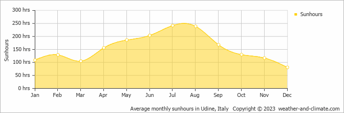
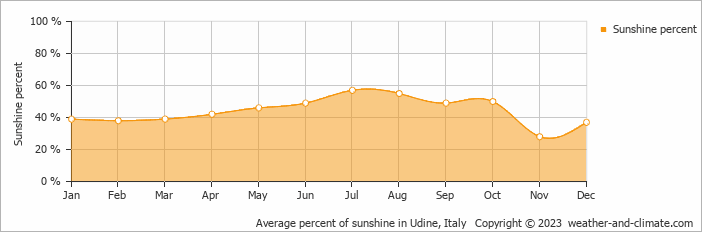
Camino al Tagliamento can be enjoyed more throughout the sunniest month of July under a blue sky, with approximately 8.1 hours of sunshine daily. In contrast, the city experiences much darker days in December, with only 2.7 hours of sunlight per day.
Visit our detailed sunshine hours page for more information.
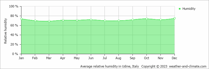
The relative humidity is high throughout the year in Camino al Tagliamento.
The city experiences its highest humidity in December, reaching 75%. In March, the humidity drops to its lowest level at 69%. What does this mean? Read our detailed page on humidity levels for further details.
Monthly ratings reflect general weather comfort, based on daytime temperature and rainfall. Swimming and winter conditions are highlighted separately where relevant.
July typically offers the most optimal weather in Camino al Tagliamento. In contrast, January, February and December tend to have less optimal conditions. Camino al Tagliamento has warm summers and cold winters.
Daytime highs range from 9°C (48°F) in January to 30°C (86°F) in August. Nighttime lows range from 1°C (34°F) to 19°C (66°F). Temperatures vary considerably through the year.
Annual rainfall is around 1379 mm (54 in). November is the wettest month with 166 mm (6.5 in), while January is the driest with 71 mm (2.8 in).
Camino al Tagliamento receives around 1,866 hours of sunshine per year. July is the sunniest month with 242 hours, while December is the cloudiest with just 81 hours.
Camino al Tagliamento is highlighted - select any city to see its climate.
Where to go in September - average daytime high across popular destinations.
Need travel inspiration? Check out our bucket list articles and be inspired.
The 10 most beautiful historical towns in Italy
Discover Italy's top 10 historic towns, featuring breathtaking medieval architecture and deep-rooted history, ideal for enthusiasts of extraordinary cities.
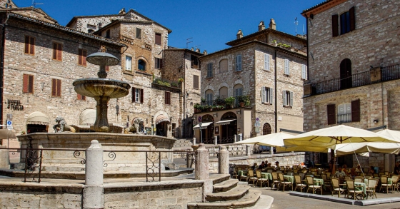 Experience mystical Assisi
Assisi is the most famous town in Umbria and best known because of Saints Francis and Clare of Assisi. Many visitors come to see the breathtaking San Francesco basilica.
 The Battle of Oranges
This is one of the most unusual festivals in Italy. The festival is held in the middle of winter during the winter carnival. The entire city of Ivrea near Turin turns into a battlefield.
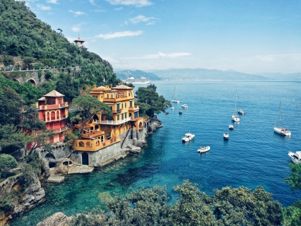 The most beautiful fishing village of Italy
Portofino is the most beautiful fishing village in Italy and maybe even in the world. We absolutely recommend that you add this beautiful place to your bucket list.