Zagora Monthly Rainfall & Precipitation
This page shows both the average monthly rainfall and the number of rainy days in Zagora, Thessalia, Greece. The figures are based on a 30-year period (1990–2020) to provide a reliable average. Let's explore the details to provide you with a complete overview.
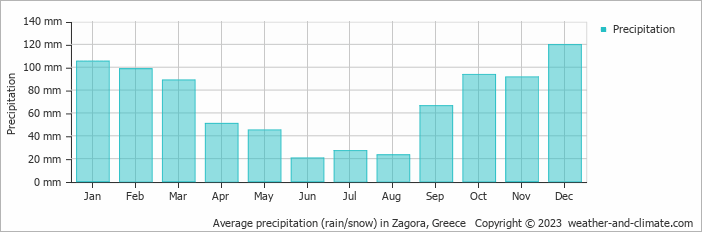
Generally, Zagora experiences moderate precipitation patterns, averaging 829 mm (33 in) yearly. However, this average masks significant seasonal variation, including a distinct dry season during certain months that are clearly visible in our monthly breakdown below.
Monthly Precipitation Levels
The average number of days each month with precipitation (> 0.2 mm (0.01 in))
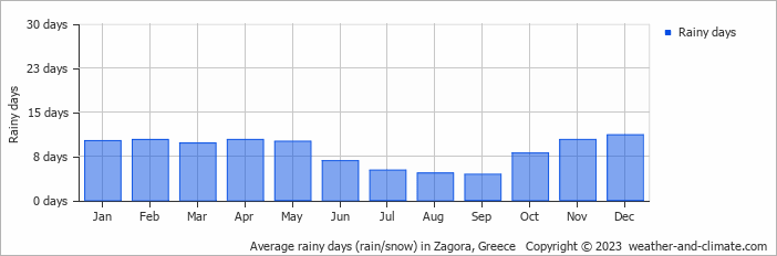
The seasons in Zagora, bring significant changes in precipitation. The wettest month, December, receives high rainfall, with an average of 120 mm (4.7 in) of precipitation. This rainfall is distributed across 11 rainy days.
In contrast, the driest month, June, experiences much less rainfall, totaling 21 mm (0.8 in) over 7 rainy days. These distinct seasonal differences provide diverse experiences throughout the year.December, the wettest month, has a maximum daytime temperature of 13°C (55°F). The city receives 109 hours of sunshine in this period. During the driest month June you can expect a temperature of 26°C (79°F). For more detailed insights into the city's temperatures, visit our Zagora Temperature page.
Annual Rainfall in Greece: City Comparison
The map below shows the annual precipitation across Greece. You can also select the different months in case you are interested in a specific month.
 heavy rainfall
 high
high
 moderate
 low
low
 almost none
Zagora vs World: Rainfall Compared
Zagora's average annual precipitation is 829 mm (33 in). Let's compare this to some popular worldwide tourist destinations:
In Lisbon, Portugal, the average annual precipitation is 774 mm (30 in), characterized by wet winters and dry summers typical of the Mediterranean climate.
Beijing, China, receives 560 mm (22 in) of annual precipitation, concentrated in the summer months.
Perth, Australia, receives 565 mm (22 in) of rainfall annually, mostly during the winter months.
Kuala Lumpur, Malaysia, receives 2529 mm (100 in) of annual rainfall, characteristic of its equatorial tropical rainforest climate, with consistent rainfall throughout the year and peak months during March and November.
Precipitation amounts are measured using specific gauges installed at weather stations, collecting both rain and snow and any other type of precipitation. Rainfall is measured directly in millimeters, while that from snow and ice is obtained by melting it. Automated systems often incorporate heaters to make this easier.
Information from these stations is transmitted via Wi-Fi, satellite, GPS, or telephone connections to central monitoring networks. This information is immediately updated and integrated into weather models and forecasts.
The proximity of a location to a large body of water can significantly affect its rainfall patterns:
- Ocean Influence: Coastal regions typically receive more rainfall due to the presence of moisture-laden winds from the ocean. These regions tend to have more humid climates and experience more frequent precipitation, especially in winter.
- Continental Climates: Areas further from the sea, such as inland or continental regions, experience less frequent rainfall and more extreme seasonal variations in precipitation.
- Mawsynram in India is noted as being the wettest place on earth, with over 11 meters (36 feet) of rain falling every year.
- In contrast, Antofagasta in Chile is among the driest places on the planet, getting less than 0.1mm (0.004 inches) per year, with some years recording virtually no rainfall.
- Nearly 1,650 thunderstorm cells are estimated over the planet at any given time.
For more detailed information about Zagora's weather, including sunshine hours, humidity levels, and temperature data, visit our Zagora Climate page.