















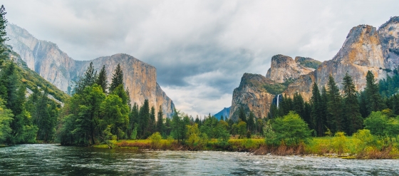
 Yosemite National Park is definitely worth a visit
Vast forests, blue lakes, towering sequoias, and majestic waterfalls hint at the beauty of Yosemite National Park—a true natural masterpiece.
This page shows both the average monthly rainfall and the number of rainy days in Channelview, Texas, United States of America. These averages rely on historical data collected over 30 years, from 1990 to 2020. Now, let's break down all the details for a clearer picture.
Channelview has a notably wet climate with abundant precipitation, recording 1559 mm (61 in) of rainfall per year.
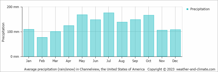
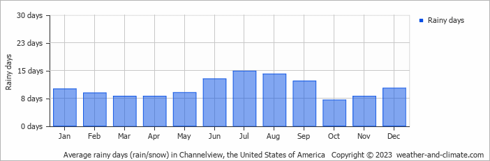
Significant seasonal changes in precipitation occur throughout the year. During the wettest month, July receives substantial rainfall, averaging 175 mm (6.9 in) of precipitation, recorded across 15 rainy days.
In contrast, the driest month, February brings less rainfall, with 76 mm (3 in) over 9 rainy days.
July, the wettest month, has a maximum daytime temperature of 33°C (91°F). The city receives 295 hours of sunshine in this period. During the driest month February you can expect a temperature of 19°C (66°F). For more detailed insights into the city's temperatures, visit our Channelview Temperature page.
The map below shows the annual precipitation across the United States of America. You can also select the different months in case you are interested in a specific month.
Channelview's average annual precipitation is 1559 mm (61 in). Let's compare this to some popular worldwide tourist destinations:
New York City, USA, receives 1276 mm (50 in) of rainfall annually, with precipitation evenly distributed throughout the year.
In Seoul, South Korea, the average annual precipitation is 1237 mm (49 in), with most rain falling during the summer monsoon season.
Adelaide, Australia, enjoys 511 mm (20 in) of annual precipitation, with dry summers and wet winters.
Bangkok, Thailand, experiences a tropical monsoon climate with 1668 mm (66 in) of annual rainfall, with the heaviest precipitation occurring during September and October.
Precipitation amounts are measured using specific gauges installed at weather stations, collecting both rain and snow and any other type of precipitation. Rainfall is measured directly in millimeters, while that from snow and ice is obtained by melting it. Automated systems often incorporate heaters to make this easier.
Information from these stations is transmitted via Wi-Fi, satellite, GPS, or telephone connections to central monitoring networks. This information is immediately updated and integrated into weather models and forecasts.
Precipitation has a very strong role in determining the local climate and ecosystem:
For more detailed information about Channelview (TX)'s weather, including sunshine hours, humidity levels, and temperature data, visit our Channelview (TX) Climate page.
Pick a month to see the average temperature, rainfall and sunshine in Channelview - and find the best time to visit.
Temperature Rainfall Sunshine Humidity Wind Speed
See the full Channelview climate overview or explore weather in the United States of America.
Where to go in October - average daytime high across popular destinations.
Miami Beach 29°C (84°F) Orlando
 29°C (84°F) Kissimmee
 29°C (84°F) Destin26°C (79°F) Los Angeles24°C (75°F) New York City19°C (66°F) Big Bear Lake19°C (66°F)
 Need travel inspiration? Check out our bucket list articles and be inspired.
Yosemite National Park is definitely worth a visit
Vast forests, blue lakes, towering sequoias, and majestic waterfalls hint at the beauty of Yosemite National Park—a true natural masterpiece.
 The 10 most alternative cities in the United States
Discover the top 10 fun and alternative U.S. cities rich in art, culture, and adventure. From Portland's hippy charm to Sedona's stunning landscapes.
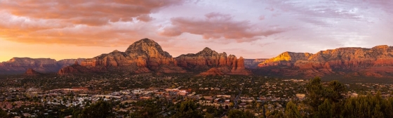 Sedona: Explore Majestic Red Rock Landscapes
A picturesque artists' town surrounded by red rocks and known for its spirituality, vortex energy, and stunning hikes like Cathedral Rock.
 10 most idyllic villages to visit in the United States
Discover 10 idyllic villages in the USA, from California to Vermont. Explore their unique charm, rich history, stunning nature, and vibrant arts scenes.