














 Visit the Rainbow Mountains
The Rainbow Mountain (Vinicunca) is acolored rainbow mountain that will steal your heart forever and the view from the top will take your breath away.
This page shows both the average monthly rainfall and the number of rainy days in Cerro Azul, Peru. The figures are based on a 30-year period (1990–2020) to provide a reliable average. Let's explore the details to provide you with a complete overview.
Cerro Azul sits in an arid zone with minimal moisture, averaging 149 mm (5.9 in) of rainfall per year.
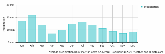
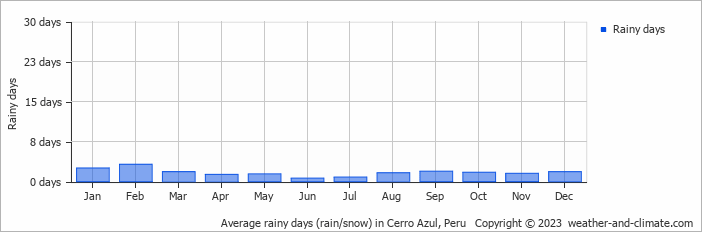
The seasons in Cerro Azul, bring significant changes in precipitation. The wettest month, February, receives low rainfall, with an average of 22 mm (0.9 in) of precipitation. This rainfall is distributed across 3 rainy days.
In contrast, the driest month, April, experiences much less rainfall, totaling 6.8 mm (0.3 in) over a single rainy day. These distinct seasonal differences provide diverse experiences throughout the year.February, the wettest month, has a maximum daytime temperature of 24°C (75°F). During the driest month April you can expect a temperature of 22°C (72°F). For more detailed insights into the city's temperatures, visit our Cerro Azul Temperature page.
The map below shows the annual precipitation across Peru. You can also select the different months in case you are interested in a specific month.
Cerro Azul's average annual precipitation is 149 mm (5.9 in). Let's compare this to some popular worldwide tourist destinations:
In Toronto, Canada, annual precipitation averages 964 mm (38 in), with snowy winters and rainy summers.
Beijing, China, receives 560 mm (22 in) of annual precipitation, concentrated in the summer months.
In Tokyo, Japan, the average annual precipitation is 1528 mm (60 in), with significant summer rains due to typhoon season.
Kuala Lumpur, Malaysia, receives 2529 mm (100 in) of annual rainfall, characteristic of its equatorial tropical rainforest climate, with consistent rainfall throughout the year and peak months during March and November.
Precipitation amounts are measured using specific gauges installed at weather stations, collecting both rain and snow and any other type of precipitation. Rainfall is measured directly in millimeters, while that from snow and ice is obtained by melting it. Automated systems often incorporate heaters to make this easier.
Information from these stations is transmitted via Wi-Fi, satellite, GPS, or telephone connections to central monitoring networks. This information is immediately updated and integrated into weather models and forecasts.
Climate change is affecting precipitation patterns worldwide, including Cerro Azul:
For more detailed information about Cerro Azul's weather, including sunshine hours, humidity levels, and temperature data, visit our Cerro Azul Climate page.
Pick a month to see the average temperature, rainfall and sunshine in Cerro Azul - and find the best time to visit.
Temperature Rainfall
See the full Cerro Azul climate overview or explore weather in Peru.
Where to go in September - average daytime high across popular destinations.
Iquitos 32°C (90°F) Trujillo
 22°C (72°F) Lima20°C (68°F) Arequipa
 20°C (68°F) Puno17°C (63°F) Cusco
 17°C (63°F) Machu Picchu15°C (59°F) Urubamba14°C (57°F)
 Need travel inspiration? Check out our bucket list articles and be inspired.
Visit the Rainbow Mountains
The Rainbow Mountain (Vinicunca) is acolored rainbow mountain that will steal your heart forever and the view from the top will take your breath away.
 "The other" Machu Picchu: the Inca City of Choquequirao
Discover Choquequirao, the hidden Inca city near Cusco. Hike through stunning landscapes and explore ancient ruins with fewer crowds than Machu Picchu.
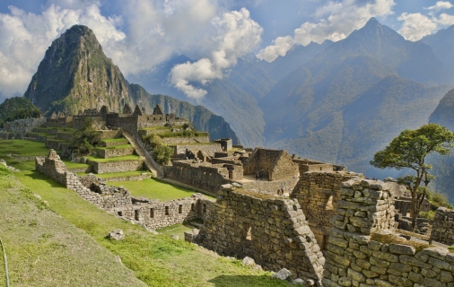 Hike the inca Trail
Few walking tours speak so much to the imagination as the Inca Trail to Machu Picchu. The tour leads through beautiful mountain landscapes and it is called the 'Royal Highway'
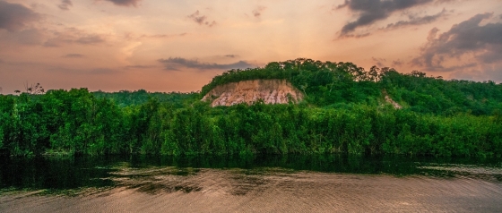 The Inkaterra Reserva Amazonica
One of your highlights during a trip in Peru might be this eco-luxury lodge in front of the Madre de Dios River, called Inkaterra Reserva Amazonica.