La Velilla Temperature by Month
The average annual maximum temperature in La Velilla, Castile and Leon, Spain is 18°C (64°F), with daytime highs ranging from 8°C (46°F) in January to 29°C (84°F) in July. This page covers monthly averages, day-night differences, and how La Velilla compares to cities worldwide.
La Velilla Monthly Temperatures
With significant temperature fluctuations, La Velilla enjoys distinct seasons year-round. Nighttime lows range from 14°C (57°F) in July to 0°C (32°F) in January.
The chart below illustrates the average maximum day and minimum night temperatures in La Velilla by month:
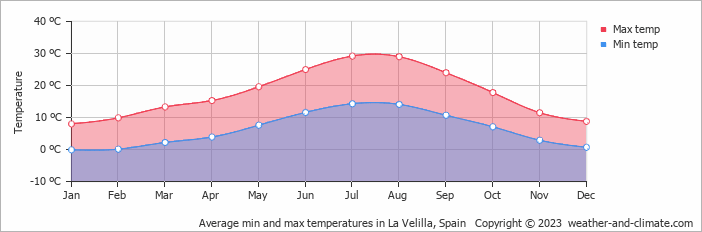
The coolest part of the day is typically between 4 AM and 6 AM, while 3 PM is usually the warmest, when solar heating is at its peak.
The chart below shows the average temperature throughout the year:
Temperature: La Velilla vs Spain
The map below shows the annual temperature across Spain. You can also select individual months if you want to compare a specific time of year.
 very warm
 warm
warm
 pleasant
 moderate
 cold
cold
 very cold
La Velilla vs World: Temperature Compared
La Velilla's average annual maximum temperature is 18°C (64°F). To put that in context, here's how it compares to a few well-known destinations:
Seville, Spain averages 23°C (73°F) a year — one of the warmer cities in Western Europe, with long hot summers.
Queenstown, New Zealand averages 10°C (50°F) annually — remember seasons are flipped, so its coldest months fall in June and July.
New York City, USA averages 17°C (63°F) a year, with hot humid summers and cold winters that bring regular snowfall.
Brisbane, Australia averages 26°C (79°F) a year, with warm winters and hot, humid summers.
Climate temperature data is typically calculated as a 30-year average. This smooths out year-to-year variability and gives a more reliable picture of what a place is actually like, rather than what happened in any single unusual year.
The readings come from a range of sources — land-based weather stations, ocean buoys, ships, and satellites. That data is collected by weather services around the world, then pooled, quality-checked, and averaged to produce the climate records you see here.
For cities and regions with significant elevation, altitude is one of the biggest factors shaping local temperatures. As a rule of thumb, temperatures fall by around 6°C for every 1,000 metres gained — so a city at 2,000 metres will typically be around 12°C cooler than a city at sea level in the same region. Higher ground also tends to see more dramatic day-to-night temperature swings, since thinner air loses heat faster after sunset.
For more on La Velilla's weather — including monthly rainfall, sunshine hours, and humidity — visit our La Velilla climate page.